Grumentum city planning
by Liliana Giardino
Grumentum built-up area took up all the raised valley indicated by the toponymy “Civita”, at the bottom of which lay the necropolis areas.
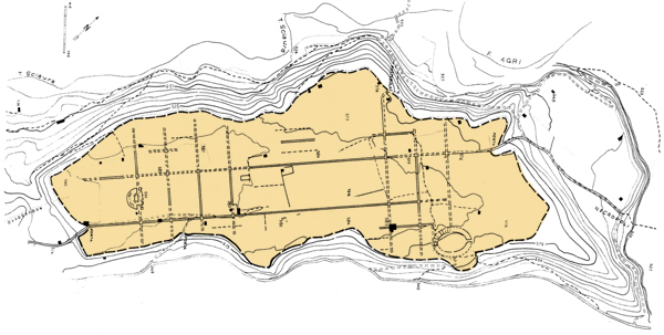
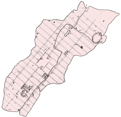
The urban center is encompassed within walls (of which some remains are visible) following the natural brow of the hill. The aerial photogrammetric surveys (i.e. taken from aerial photos) and some excavation tests revealed the presence of six city gates, four of which reserved for the wagons passage, and two smaller gates (in latin posterulae) for the pedestrians. None of the gates has been archaeologically investigated, but all have been identified with certain tracks on the ground. The most important gate was so-called “Aquilia”, a scea gate located on the south side, close to the St.Joseph chapel. The urbanistic layout is marked by a grid of streets intersecting in a right angle. Towards north/east-south/west are developing three lengthwise streets (decumani), parallel to the two long sides of the walls, crossing the whole town in its length and are located on the three natural terraces of the ground (the central one is in a raised position compared with the other two). The expert Giulio Schmiedt, basing only on the interpretation of aerial photographs, identified an orthogonal urban road fabric consisting only of two longitudinal axis north/east-south/west, cut by a series of crossroads in a constant form of 60 meters approximately. So the mesh created in this way would have a basilar city block of about 60 x 100 meters.
The structure of the system is strongly influenced by the natural flow of the hill; the whole area approximately is wide 25 hectares (950 x 240 meters). In the surrounding of the theater, the excavations have documented that the orientation of the urban plan, created in the first half of the third century B.C., so probably in conjunction with the foundation of the city, was respected until the abandonment of the city, dating between the sixth and the seventh century. Some excavations permitted to notice that under two of the three longitudinal axis of imperial age (the central and the eastern ones) there are remains of older streets, of republican age (first half of the third century B.C.). These roads, large respectively 5,20 and 7,40 meters, had a river cobblestone paving and didn’t have any sidewalks; moreover, the eastern side still keep a not paved zone, presumably intended to the open outflow of the rainwater. Many transversal axis, dating at the beginning of the second century B.C. and south/east-north/west oriented, have slightly different characteristics: they were large about 4 meters and the paving was made by a layer of pressed mold and rubble.
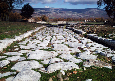
The imperial road fabric, used until the sixth century, has the particular humpback pattern; the width of the main axis is 4 meters, plus the thickness of the crepidine. Nowadays is clearly visible for large stretches the road axis running along the central terrace, at various points along its length. |


 Thanks to a series of essays, it’s now possible to assume the existence of a third longitudinal axis on the western terrace. Each of the three axis is transversely cut by roads towards south/east-north/west (cardo), situated at regular intervals of 35 meters, to be more precise a
  In the second half of the second century A.C. was carried out a massive resettlement of the urban road network: the three main roads, oriented north/east-south/west, and some of the crossroads were restored using grayish limestone slabs, carefully connected; the roadway is bounded on both sides by a cordon of parallelepiped shaped blocks (crepidine), also in limestone.